Sustainable Runoff Management
Rethinking City Flood Protection
In the heart of Tel Aviv, the Argazim neighborhood has long struggled with frequent flooding, primarily caused by overflow from the Ayalon River and an insufficient municipal drainage system. Residents and city officials recognized that the existing infrastructure was no longer adequate to protect the area during heavy rains, making it necessary to explore comprehensive solutions that could reduce the neighborhood’s vulnerability to flooding.
To address these challenges, a detailed hydrological modeling process was initiated, which included mapping the relevant sub-catchments, analyzing the flow patterns of the Ayalon River, and assessing the current state of the municipal drainage network.
By running multiple scenarios, the project team was able to pinpoint the most effective strategies for upgrading the drainage system. The analysis didn’t stop at conventional approaches; it also incorporated Low Impact Development (LID) solutions, such as diverting stormwater into nearby parks and gardens, thereby using green spaces to help manage and absorb excess runoff.
The outcome of this process was a comprehensive report presented to Tel Aviv municipality’s directors and managers, outlining a range of options and their respective costs. Ultimately, the study demonstrated that implementing LID strategies was more cost-effective than simply increasing the diameter of drainage pipes. This approach not only addressed the immediate risk of flooding but also provided long-term benefits for the neighborhood’s resilience and urban environment.
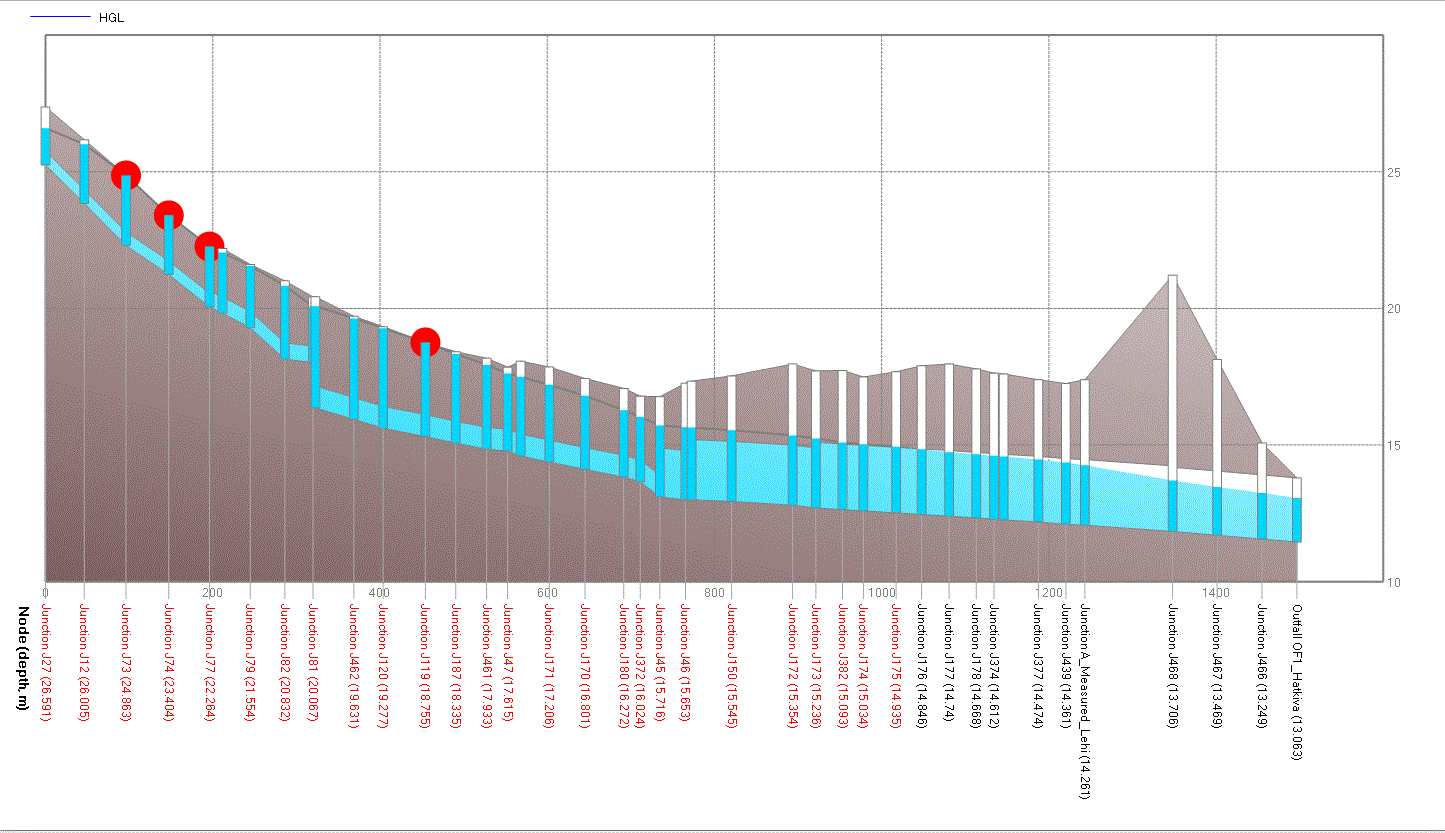
The first step was a detailed hydrological modeling, which included mapping the topography and flow channels. Analyzing the flow patterns of the Ayalon River, and running 2D model to get the pluvial floodplain and flood volumes. All the drainage outlets are going to the river, and when it floods, the drainage system is also flooded.

The second phase entailed identifying suitable public land areas, including parks and green spaces, that could serve as stormwater retention and infiltration facilities, followed by quantifying the surface runoff volumes that could be redirected to these areas.
on the right:
1D model of inspection of the drainage system during peak hour storm event. The red X are manholes overloaded and flooding.
On the left:
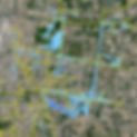
Potential public places for runoff management in the urban watershed.

Solve your Runoff Management challenges
Tell us your challenge — we’ll recommend the solution that fits your needs best, maximizing value and compliance.